Tuesday, July 19, 2011

The Snow Bird Hut

Raina was psyched to get out for the day with me to go check out the new Snow Bird hut.  I packed to stay the night since I had a couple days off.


It was a beautiful hike up the valley toward the glacier, there is a pretty nice "trail" that has cairns in quite a few places.

Raina coming down the pass onto the Snow Bird glacier


Looking down Bartolf creek toward the Kashwitna River


I have decided the Snow Bird hut is my new favorite place to be.  I could sit up there for hours and just look at the mountains.  Its also going to be a sweet base for early season skiing!!!

The new Snow Bird Hut


T.5ish:D.5.3:EG.3000

Thursday, July 14, 2011

Above the Exit Glacier

It was my day off and I wanted to get out of the rain if possible, so I went and looked at web cams, I figured I was willing to drive 2 hours in any direction for the possibility of sun shine. Weirdly enough Seward was showing blue skies, so I decided to head to Exit glacier and hike the Harding Ice field trail.

It wasn't exactly blue bird by the time I got down there, but it wasn't raining either. I was shocked by the hundreds of cars and people in the parking lot. The further up the trail the less people I saw, but I was still surprised by the number of people out there.


This is one of the nicest trails I have ever been on in Alaska. There are literally rock steps in places, amazing! .
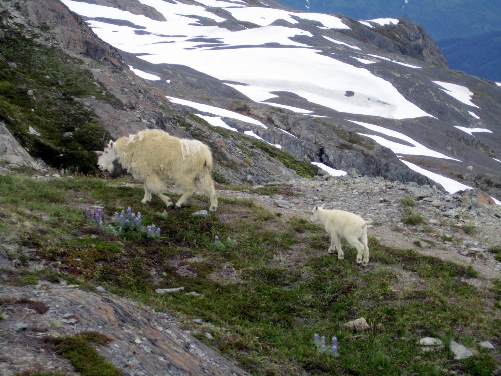
A mamma goat and baby were completely unperturbed by my presence.


I stayed the night, because I have an attraction to waking up in beautiful places, and nothing better to do. Sometime during the night the winds picked up and by morning I woke up with the wall of the tent on my head. Not exactly the relaxing 2 cup of coffee morning I had anticipated. Seeing no reason to stay in bed with a tent on my head, I headed over to the mountain shelter to make my coffee and decide the course of the day.


Not Bad Views

 
Posted by Picasa

In the end I decided the cold wind wasn't real conducive to my relaxing morning, and after coffee I headed back down the hill.  A super nice trip out of the house in a place that I haven't been in over 10 years.

Monday, July 11, 2011

Berry Pass to the 20 Mile River

A pretty impressive showing of girl power met at Carr's Huffman at 8am on a Monday morning.   By 11, all six of us we were hiking on the Winner Creek trail up to Berry Pass.

It was an overcast, muggy day, but it seemed to magnify the greens in the rain forest. 


Hiking without trails is the most sure fire way to appreciate an amazing trail the next time you are on one.  The trail has been extended on the 20 mile side of Berry pass, rumor has it, eventually it will extend all the way out to the highway. 


 This is the second time I've been with a virgin packrafter on this trip and I'm not convinced that this is the best river to start on.  The first bit is fast and tends to suck newbies into the alders along the side, its painful and scary to watch.  Poor Margo was wet, cold and scared within the first 5 minutes.  Luckily the latter half  is  mellow, if not a little unrelentingly flat and slow . What makes this trip worthwhile are the beautiful views and ability to chat the whole way.

Merrick towed me for a little while, it was pretty entertaining.


Posted by Picasa


I absolutely had a great day, but an all together different experience than I usually seek. Its funny how a small group outing can turn into a larger one, and my reaction to that. I'll just be lame and say it, but I don't like doing outdoor trips with more than 3-4 people. My patience to wait for all the separate pieces just isn't there.

T.9ish:D.24.6:EG.2760

Thursday, July 7, 2011

Resurection Creek

I called Heather up one random afternoon and an hour later I was on my way to meet her to go float Resurrection creek out of Hope. We hiked up the Resurrection trail about 5 miles where the trail follows the river and then heads away from it again. It looked a lot splashier than I had envisioned.


I can't believe I have never done this float before, nor have I heard people talking about it. It was awesome! Clear water, small drops, tight maneuvering, beautiful eddies, and face shots. Heather and I grinned the whole way down.


The fun continued past the foot bridge over the creek, but towards the end we started to get shut down by river wide strainers. After a couple portages and what looked like more to come we took out by someones cabin and walked about 5 minutes to Hope where we had left a car. It was an awesome float, way more interesting and exciting than I had ever dreamed.

 
Posted by Picasa

Saturday, June 25, 2011

Day 8: Yanert River to the Land of Cold Beer and Soft Beds

It was exciting to wake up and realize that we had one more float and then 8 or so miles on ATV trails and we would be back to civilization. The Yanert river was a super mellow float with one section of easily avoidable rocks. It was amazing after walking so slow for days to have the miles fly by with little effort, it made carrying the boat well worth it.

Ryan Floating the Yanert


We took out at Moose creek and found evidence of humans before us, a fire ring and trash.  There was a small trail that paralleled the river and eventually dumped into a larger four wheeler trail on the other side of Revine Creek. 


Pretty amazingly easy walking took us to a neighborhood where we could hear the highway but not see it.  I wanted to cut over through the trees but Lynn and Ryan definitely put the kabosh on that plan. 

 
Eventually we could see the airstrip and cut across the end of it and ended up at a lodge right next to the highway.  With cell phone service we made reservations at a hotel and arranged a pick up to take us to McKinley village.


My good buddy Rapheal drove up to get us, we were supposed to stay out late and dance to Big Fat Buddha. But after gorging myself I went into a food coma and needed to lay down.  No amount of heckling from Rapheal could bring me out of my stupor,  I was done for the night.

 
Posted by Picasa


Although my GPS was broken for the last 2 days I left it on while we traveled and was able to down load the tracks when I got home. The trip was about 130 miles with 19,000 feet of elevation gain.  We crossed 2 glaciers, and went over numerous passes and rivers. It has taken a while to digest the vast swathe of land we walked across, and go through the hundreds of pictures along the way.  A worthy trip, although one I probably won't do again.

T.9:20:D.22.8:EG.420

Friday, June 24, 2011

Day 7: Little Grizzly Creek to the Yanert River

I can't adequately describe the joy and optimism for life that I felt when the early morning sun hit my face. It felt like days since it had been nice out, if it was sunny everday could I ever be this appreciative of it?

After a lot of debate we put back in the Wood river and decided to take out at Little Grizzly creek with the hope of finding a horse trail I had read about on one of Roman Dial's posts. We all just wanted some nice easy walking.


A flash of aviation orange caught my eye as we were approaching Little Grizzly creek, we pulled over and found a large airstrip and about 100 yards into the trees the Denali Wilderness Lodge. No one was home, I guess its for sale. If I was a gazillionaire I would buy it in a second. It was a huge compound comprised of a large lodge, numerous private guest cabins, an old tractor, and horse pens. It was all the more impressive considering everything there was flown in.


There was no sign that marked the start of the horse trail, and I would have said it was more like a game trail, except that it didn't dead end as often. We followed it up the creek, lost it and found it as it crossed the creek back and forth, once above treeline though it was awesome to the top of the pass.


We should have stayed left instead of right when we lost the trail, but we didn't know how or if it went all the way to Yanert river anyway. The important thing is we saw it where it crossed Dick Creek and went up the left bank about 500 ft. I have no doubt that it would have never ending bushwhack on the opposite side.


It felt like miles to get through the trees and down to the Yanert. Luckily the summer days are long because we didn't make camp till midnight. Our feet were wrinkled, and aching, but we were grinning because now it was time to float again.

 
Posted by Picasa


Sun Setting Over the Yanert River


T.15:D.20:EG.3000

Thursday, June 23, 2011

Day 6: Another Pass to the Wood River

Five days of walking on tussocks, rocks and through rivers took its toll on our feet.  Ryan's ankle was swollen and his feet covered in duct tape.  Luckily for us the walking was really good up the West fork of the Little Delta.


Across from a little cabin that seemed grossly out of place on the river in the middle of nowhere we cut up an unnamed drainage following a creek with iron stained rocks.  The clouds threatened rain, but only produced brief sprinkles.


We climbed to another 6,000 foot pass through the clouds.


As we came down we could start to see the Wood River, the prospect of floating at this point sounded like entering heaven.


We got to the Wood River at about 7 and were all excited to start floating.  We debated going up Grizzly creek, or floating another 4+ miles to Little Grizzly creek across from the closed down Denali Wilderness Lodge.  The Wood river was running swift through small braided channels, there was quite a bit of intermittent but scooting through shallow sections.

 
Posted by Picasa
I pulled my GPS out of my life jacket to see how fast I was floating and immediately saw the cracked touch screen.  No amount of further touching would bring it back to a functional state.  I'm embarrassed but I cried like a baby for at least 2 hours.  I love knowing exactly where I am and the ability to satisfy my curiosity about my exact distance, pace, elevation gain/loss, way points, ect was swiftly and unexpectedly gone.  We pulled out at Grizzly creek and camped for the night.


Geekery Courtesy of Garmin

Wednesday, June 22, 2011

Day 5: More Passes To and From Buchanon Creek

Rain and mosquitoes, my favorite morning combination of suffering. I've never seen such an impressive amount of bugs in a mega mid before, needless to say it wasn't a place that encouraged loitering in the morning. We packed up and headed up valley. Shortly after starting out Lynn says, "bear" we all stop and about 100 yards ahead of us is 3 bears, a mama with two cubs that looked at least a year old. We backed away, and they stood on their hind legs to get a better look. Although they were initially curious, they decided they didn't like us either and headed up the opposite side of the valley, thankfully in a different direction than we were trying to go.


Ryan Looking Down to Buchanon Creek


Walking up the Buchanon was a welcome relief from the sponge land tussock crap we had been unable to stray from, it was not however a smooth river bar, virtually no sandy sections. Lots of jumbled rocks, wherever we saw snow we changed course to walk on it.


As we winded up the river into the clouds, it narrowed and the mountain of scree came in closer.


The pass I'm sure was spectacular as we were at 6,000 feet surrounded by big mountains we could only see on the map. I always feel like when I miss the view I need to go back, this trip might be the exception. It felt like we were super remote and everything was farther away than it looked!

We descended the pass into another valley with another creek we ping ponged down and across. There were some wet aching feet, and no duct tape or blister remedy could withstand the constant wetness. We stopped shy of the West fork of the little Delta in a pause from the rain on a flat spot that seemed made for the mega mid.

 
Posted by Picasa


T.?:D.14:EG.2720

A little geekery courtesy of Garmin


Tuesday, June 21, 2011

Day 4: Whistler, East Fork, and Above the Gillam Glacier

Its hard to get going when its raining out, but it helps when its also raining in the mega-mid when people move. Our bug shield was effective, but the buried flaps caused the sides to sag...needless to say it wasn't a beautiful morning.


After much debate due to high water and lots of rain we decided not to go down Hayes creek to the East fork river and instead cut across a bench and dropped into Whistler creek which took us to the East fork. From there it was a nice change to walk on rocks, gravel and cross the creek.


The channels on the East fork river varied but some of them were deep, others swift, and some swift and deep. We spent a fair amount of time in the water.


There was lots of debate the whole way up river about whether we could cross the main channel on foot, but it never looked quite good enough. Eventually the river hugged the side of the mountain and we had to cross. There was a little debate, but in the end we all blew up our boats and crossed, it would have been gnarly to try and cross by foot.


Near the toe of the Gillam glacier we cut over to the base of the unnamed valley that would take us to Buchanon creek. It was a little bit of a bushwhack, and when we stopped to get some water Lynn noticed her poles for the paddles were missing from her pack. In the rain, surrounded by bugs and bushes, I think we all wanted to cry. Instead we left our packs and tried to follow the GPS track back. It was quite difficult to stay on route, but we found one pole, went all the way back to the river, and on the way back to our packs found the other pole. It was like looking for a needle in a haystack. Losing the paddles could have significantly altered our trip.

 
Posted by Picasa


From there we schwacked hard uphill in the pouring rain for about an hour until we reached the ridge where an amazing game trail was. I love game trails, its amazing how much easier they make traveling. We made it to a bowl above the Gillam glacier, found a reasonably flat place and set up the mega mid.


T.13.2:D.17.4:EG.2370